
From wild flowers to historic houses: the 10 best National Trust walks for spring
The seasons dominate the British countryside. The new leaves and buds of spring, the blazing skies of summer, the golden leaves of autumn and the frozen earth of winter – and National Trust properties around the country showcase the seasons to their best advantage.
The Trust is responsible for nearly 613,000 acres of land, almost 775 miles of coastline and more than 300 historic buildings across England, Wales and Northern Ireland, so whether you want to see ancient woods, dramatic clifftops or landscaped gardens, you’re spoilt for choice when it comes to finding a walk at a National Trust property. A new guide, Great British Seasonal Walks, features 100 walks on National Trust property, divided by season. Here are some of our favourites for spring.
Salcombe Hill to Sidmouth Circular Walk
Salcombe Hill, Sidmouth, Devon EX10 0NY
OS Map: Landranger 192
Start/End: National Trust Salcombe Hill car park, OS grid ref: SY 148889
Distance: 5 miles
Time: 3 hours
This spectacular circular walk showcases the Regency town of Sidmouth. Starting with the stunning views across the Sid Valley, the walk takes you down into Sidmouth town through the woods and fields of Salcombe Hill and then upriver through The Byes, Sidmouth’s lovely, tranquil riverside park. A walk in the spring provides an outstanding display of bluebells in the woodland of Soldier’s Hill as well as being a wonderful time of year to enjoy the Devon coast.
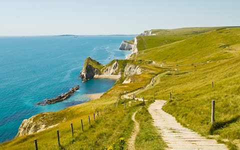
Look out for… views of the Jurassic Coast
Covering around 95 miles, the Jurassic Coast stretches from Exmouth to Studland Bay, and spans 185 million years of geological history. Coastal erosion has exposed rock formations that form an almost continuous sequence from the Triassic, Jurassic and Cretaceous periods, providing evidence that over time the area has been desert, shallow tropical sea and marshland.
Between the village of Sidford and the Old Toll House of Sidmouth, The Byes riverside walk stretches one-and-a-quarter miles. You might spot dippers, kingfishers, tawny owls and even otters playing in and around the fast-flowing river.
Take the path past the picnic tables and follow the Salcombe Hill Cliff and Link to Coast Path sign.
Follow the footpath to the cliff where you can enjoy fantastic views of Sidmouth and beyond.
Follow the path to the right, then take a path on the left signposted “Coast Path Sidmouth ⅔ mile”. Go down through a small woodland and across a field. Turn right at the end by the Coast Path.
At a junction, turn left onto Laskeys Lane then continue along the footpath next to West Combe House and into Cliff Road. Follow the footpath to the left down the hill and across a temporary bridge over the mouth of the river Sid.
Turn right and head inland along the left side of The Ham (a small park), past a seascape mural.
Continue along the path and then straight ahead along the National Cycle Network path along Riverside Road. Turn right onto Mill Street by the car park and cross over a footbridge at the ford before continuing along Milford Road.
At the junction, cross the road and enter The Byes riverside park. Follow the path upriver along the side of the river Sid, crossing over the third bridge, signposted Sidford.
Walk upriver towards Sidford through Margaret’s Meadow and the Gilchrist Field until you reach a cycle path junction. Turn right following the “Fortescue ¼” mile sign crossing a bridge and through some gates, and out onto Fortescue Road.
Turn left and follow a quiet road before turning right into Griggs Lane towards Salcombe Regis.
Follow lane and woodland path up the hill, through a kissing gate marked “Soldier’s Hill ¼ mile”. At the end of the path continue across the field and through another kissing gate onto Salcombe Hill Road.
Turn right, then left at the war memorial. Take the path to the right through the SVA Allotment Field Wood kissing gate; turn right following the Link Path to Salcombe Hill sign.
Follow the path around to the right and down some steps, then follow the sign marked “Link Path Salcombe Hill”. Turn left and then right at the Salcombe Hill and car park sign. Turn right next to a barn and follow the track back to the car park.
Leigh Woods Woodland Wander
Leigh Woods National Nature Reserve, Bristol BS8 3PL
OS Map: Landranger 154
Start/End: North Road entrance, OS grid ref: ST 555730
Distance: 1 mile
Time: 30-45 mins
This walk runs through beautiful woodland with rare and veteran trees as well as grassland. In spring the woods are covered in a carpet of bluebells – a must-see at this time of year. Stokeleigh Camp hill fort is perched on the edge of the Avon Gorge and there are dramatic views along the river.

Look out for… rare trees
Leigh Woods has long been recognised for its rich natural environment, including an abundance of rare whitebeam trees. They contain nearly every indigenous tree in the country, and offer a foliage of singular varied tint, from the darkest yew to the pale light green of lime and oak. The woodland in spring, when the trees are coming into leaf, is a stunning sight.
Go through the kissing gate and up the sunken track straight ahead.
This brings you out onto an open grassy area. Cross this, sticking to the right-hand side. You’ll walk past a line of whitebeam trees.
Take the small path that runs along the top of the valley and straight on to another grassy area.
Ahead of you are the ramparts of Stokeleigh Camp, an Iron Age hill fort. Follow the narrow rocky path through these; it can be slippery.
Follow the grassy path straight ahead for 200m to the viewpoint.
Turn left and follow the path along the gorge side for 300m, back through the ramparts and past a fenced pond.
Turn left onto the Purple Trail, where you can see the dramatic sweep of the ramparts.
Turn right and follow the Purple Trail to the stone wall.
When you reach the parish wall leave the Purple Trail and turn left following the stone wall. Go straight through the gate after 200m and join the Blue Trail.
Follow the Blue Trail straight ahead. Once you reach the ancient yew that grows in the line of the wall, the path should curve away from the wall.
Carry on past the low wooden building, the National Trust office. Follow the gravel road and look out for the blue-topped waymarker on the left.
Follow the Blue Trail back downhill to the start.
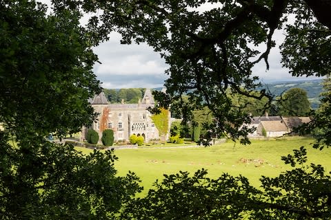
Sissinghurst Castle Estate Walk
Sissinghurst Castle, Biddenden Road, near Cranbrook, Kent TN17 2AB
OS Map: Landranger 188; Explorer 136
Start/End: National Trust car park, OS grid ref: TQ 807384
Distance: 3 miles
Time: 1 hour 30 mins
The estate is set in 460 acres of beautiful Wealden countryside that comes to life during the spring. Crocuses and daffodils start the season off in a flurry, dotted around the woodland and in the surrounding fields. April sees the bluebells come into their own, creating a carpet of purple amongst the trees.

Look out for… the Gazebo and the Tower
The Gazebo, in the corner of the garden, looks out over the estate and Wealden countryside. It was built as a memorial to Harold Nicolson (author, politician and husband of the writer Vita Sackville-West). Built in the 16th century, the Tower was used as a viewing platform for deer hunts on the 700-acre deer park surrounding the Elizabethan house.
From the car park follow the path towards the castle. Walk to the left of the castle and continue along the moat, following it round to the right at the Gazebo. Continue along this path, through a gate and downhill towards the lake. At the bottom of the field, go through the gate and turn left around the Lower Lake.
After crossing the second bridge, turn right and continue along the Ride through the traditional coppice woodland.
After 350m bear left then right and continue 420m along the ride until you reach the edge of the woodland. Turn right down a narrow path and cross a stile into Park Field.
Bear left across the parkland, taking in the views of the castle. At the next stile cross the drive and enter Bull and Birches Woods. Follow the path for 60m, then turn right along a public footpath up the field. At the top turn right, pass through the second double gate then bear diagonally left across the Orchard.
Join the bridleway, passing the vegetable plots on your right and continue along this track. Turn right into the field and follow the margin until you come to a gate.
Bear right onto the lane and follow this to the next gate on your right.
Go through this gate onto the path, continuing over the stream back to the castle.
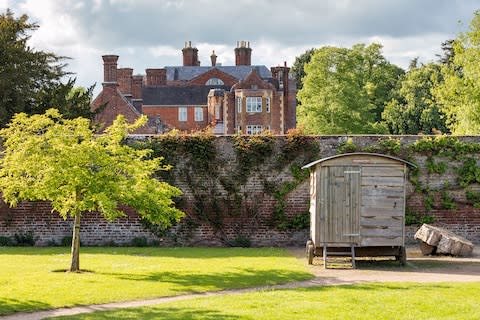
Melford Hall to Lavenham Railway Walk
Long Melford, Sudbury, Suffolk CO10 9AA
OS Map: Landranger 155
Start: Melford Hall car park, OS grid ref: TL 867462
End: Lavenham Guildhall, OS grid ref: TL 916493
Distance: 4.5 miles
Time: 2 hours
This walk provides the opportunity to see wild flowers, birds and animal wildlife in their natural habitat – and springtime is one of the best times of year to do this. Starting and finishing in these two well-preserved medieval “wool” towns, you can return to Long Melford by bus, or retrace your steps – if you have the energy.
Look out for… the railway line
The line (single track with passing places) from Melford to Bury St Edmunds opened in 1865. The line closed to passengers in 1961 but continued to be open for goods traffic until 1966; the line closed completely in 1967. Long Melford Railway station building still exists, (now a private house) and is located at the southern end of the village by the Old Maltings. This walk largely follows the route of the old Great Eastern Railway. Selected areas of the banks of this cutting are being returned to grass, and others left as semi-natural woodland. The grassland provides a valuable habitat for insects and wildlife.
Many species have been recorded along this disused railway line, including common and lesser whitethroat, blackcap, goldcrest, treecreeper, bullfinch, garden warbler and marsh tit, along with pied flycatcher, redstart, whinchat, firecrest, red warbler, waxwing, little egret and red kite.
From the car park, turn right out of the gate and walk 600m to the Cherry Lane Garden Centre. Entering it, look for the public footpath sign in front of you, known as Hare Drift.
Hare Drift continues along a concrete path until joining the main A134 Sudbury to Bury St Edmunds road. Cross it with care, go through the gate on the opposite side and follow the footpath, which after 90m continues downhill.
At the bottom of the hill turn left and follow the tree line ignoring a footpath sign to the left. Exit through the trees on the right-hand side after about another 100m or so.
Continue across a small bridge over Chad Brook, heading uphill until exiting into a plain with scrub to the right. You can see signs now covered with scrub, showing where the path was/should be.
Head up the plain for about 180m keeping the scrub to your right, until the path runs alongside some woodland to the left.
Follow the path for 360m until reaching a path crossroads. The section after this is a permissive footpath; dogs should be on leads.
Keep on for about another 180m or so until the path rises up to the old railway embankment as you enter Lineage Wood to your left and Paradise Wood to your right. This is the site of an 1891 railway derailment.
When exiting the woodland/embankment, the route to follow is directly opposite you, but you will need to walk along the line of trees to your left, circumnavigating the open field until you reach the narrow entrance in the wood to your front. Follow the wooded path until you reach a section of railway cutting designated as a Site of Special Scientific Interest (SSSI).
You will have reached the end of the SSSI section when reaching the Bridge Street railway bridge. The next section is now known as the Lavenham Walk.
Continue on the Lavenham Walk until reaching some gates and the Park Road crossing.
Crossing the road, go through the gates, and continue on for approximately 440m until reaching Lavenham High Street.
Cross the road and continue right up High Street, for 270m; turn left into Market Lane, walk up to the Market Square and Lavenham Guildhall.
Spring Walk at Croome
National Trust Croome Visitor Centre, near High Green, Worcester, Worcestershire WR8 9DW
OS Map: Landranger 150
Start/End: National Trust Croome Visitor Centre, OS grid ref: SO 888451
Distance: 4 miles
Time: 1 hour 30 mins – 2 hours
This relaxing circular walk around the outer parkland at Croome offers superb views across the Worcestershire countryside to the Malvern Hills and great spots to see Croome’s spring flora and fauna.

Look out for… the Chinese Bridge
This is an exact replica of the original bridge, created using images from a painting by Richard Wilson in 1758 of Croome and also a book from 1749 called Developments in Architecture and Carpentry.
From the visitor centre, follow the path through the Wilderness Walk shrubbery (look out for flowering bulbs) to a gate, which brings you to the top of Church Hill. Walk around the front of the church and pass through a gate into Church Shrubbery. Follow the path, passing the hide on your left.
Follow the path, crossing a road. Continue until you reach the Rotunda. Follow the path to the right down through the Home Shrubbery to the gate at the bottom.
Enter the park and follow the path to the right towards the court and the Chinese Bridge.
From the bridge, staying on the court side of the river, follow the mown path alongside the river for just under a mile until you reach a stile. If you are lucky you will see a kingfisher or a heron. Cross the stile and walk clockwise around the pool.
Cross over a small bridge. Turn left across a wooden platform into the shelter belt – a wooded area where you might spot muntjac deer.
Follow the path for about a mile through the woods until you reach the end of the shelter belt.
At a National Trust sign turn right, go through the gate and turn right into the field, follow the fence along the shelter belt back in the direction you have walked.
You will reach three gates on the right, go through the gates until you reach the farm road.
Turn left and walk along this road until you see a large gate on the right back into the park. Go through it, turn left and on the left you will see another gate into the lake area.
Enter the lake area and follow the path to the right past the remains of the derelict Boat House. Whilst walking around the lake, look out for spring flowering primroses, daffodils and bluebells.
Where you meet the main path round the lake, turn left and cross the two white bridges linking the island to the main path. Follow the path around the lake, past the Grotto, until you reach the Dry Arch Bridge. Turn left under it and follow the path, past the Temple Greenhouse.
Continue through the shrubbery back to the church and the visitor centre.
Newton Pool Coastal Walk
Low Newton, Northumberland NE66 3EH
OS Map: Landranger 75, Explorer 340
Start/End: Low Newton car park, OS grid ref: NU 239248
Distance: 1 mile
Time: 30-40 mins
Enjoy a gentle walk alongside the Northumberland coast with plenty of wildlife-spotting opportunities along the way. In spring thousands of birds arrive for the start of the breeding season.

Look out for… Dunstanburgh Castle
Savour the great views of the magnificent ruin of Dunstanburgh Castle to the south and, on a clear day, the distant Farne Islands to the north.
Oystercatchers and other shore birds may be visible around the Emblestones, an outcrop of hard volcanic rock protecting Newton Haven from the ravages of the North Sea. Sometimes seals can be spotted basking at the far end of the rocks.
Start at the car park above Low Newton. Head downhill to the village square. Low Newton is an 18th-century fishing hamlet, with whitewashed cottages and a historic pub.
At the square take the right-hand turn, following the road by the National Trust information board.
Turn left behind the Ship Inn and follow the road south, past the back of the cottages, parallel with the seashore. Continue past the Boat Park, checking the field to your right for wetland and coastal birds on the muddy scrape.
Continue past Risemoor Cottage, a former fisherman’s pub, through a small woodland path until you see two wildlife hides facing into the waters at Newton Pool.
Continue southward; after about 30m the path forks. Take the left track past some beach bungalows in the dunes. Head for the centre of the green space where a waymarker shows the path through bracken leading to the beach.
Take in the views of Dunstanburgh Castle before turning left on the beach and heading back toward the village.
Dudmaston Hall and Dingle Walk
Dudmaston Estate, Quatt, near Bridgnorth, Shropshire WV15 6QN
OS Map: Explorer 218
Start/End: National Trust Orchard car park, OS grid ref: SO 746887
Distance: 0.8 mile
Time: 40 mins
Surrounded by traditional woodland and a lakeside garden, Dudmaston Hall has been a family home since the 17th century and offers lovely walks teeming with history and wildlife. Bluebells are a favourite at Dudmaston, and this walk provides the opportunity to spot these pretty springtime blooms, together with daffodils and snowdrops – depending on the timing of your visit.
Look out for… the Dingle
The wooded valley was a pet project of Francis Whitmore who, along with her husband William, resided in Dudmaston between 1775 and 1815 – she was a keen botanist. Together with Walter Wood, their head gardener, they created a picturesque route over rustic bridges and past waterfalls, urns and a hermitage.
Dudmaston is home to a variety of species. Dippers, grass snakes and dragonflies are regular visitors to Dudmaston’s rivers and pools and there are signs of otters. The orchard is the perfect place to relax.
Leave the orchard car park via the kissing gate at the entrance. Turn right and follow the signs downhill to the Dingle.
Proceed through the gate and follow the trail downhill. Go through a second gate and enter the woods. Take the steps to your right before you reach the brook.
Continue along the path passing the Rustic Bridge on your left. Crossing the bridge takes you on one of many other walks in the grounds of Dudmaston Hall.
Follow the trail along the forested riverbanks of the Dingle. After passing the Mill Pool on your left you will reach the Big Pool Dam. Take the path to the right, signposted for Dudmaston.
Continue along the banks of the Big Pool, passing the Boat House as you go.
Enter the pedestrian gate and cross the meadow towards the hall.
At the marked gate, you may enter the garden and make your way to the hall, or turn right and continue up the hill to your starting point at the car park.
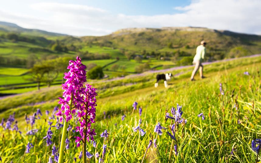
Yockenthwaite to Cray Wildlife Walk
Upper Wharfedale, Yockenthwaite, North Yorkshire BD23 5JH
OS Map: Landranger 98
Start/End: Yockenthwaite Bridge, OS grid ref: SD 904790
Distance: 6 miles
Time: 2 hours
Discover a landscape of limestone pavement, glaciated valleys and flower-rich hay meadows in the glorious setting of the Yorkshire Dales. Springtime is when the flowers begin their dazzling display and the birds start to breed.
Look out for… wild flowers and bird life
The first signs of spring arrive with wood anemones, primroses, lesser celandines and the smell from the wild garlic; later in the spring cowslips, mountain pansies and early purple orchids start to appear. These flowers then start to support the dormant insect population. Bees that have spent the winter hibernating in holes in trees and the gaps in drystone walls emerge looking for some sweet early nectar.
There is a strong bird population in Upper Wharfedale – you will begin to hear and see oystercatchers, lapwing and curlew in March with the wintering blackhead gulls beginning to show their distinctive (black head) breeding summer plumage. From April onwards, you will begin to notice the golden plover and skylarks on the fell tops on Buckden Pike.
Start at Yockenthwaite (meaning “Eoghan’s clearing in a wood”) Bridge and follow the footpath signposted to Scar House. Turn right off the farm track at another footpath sign, going through Strans Wood and emerge onto the open hillside.
In 1652, George Fox, the founder of the Quakers, stayed at Scar House and “converted the farmer to the Quaker Truth”. The house later became a Quaker meeting place. A small enclosure with five trees marks an old burial ground. Continue towards Cray, keeping the woodland boundary on your right. (For a shorter walk, turn right at Scar House and follow the track into Hubberholme). Enjoy the view down Wharfedale’s glaciated valley with its wide floor and ice-carved steep sides.
Cross Crook Gill and carry on through hay meadows to Cray. Hay is a valuable crop to farmers and it can suffer if trampled by too many feet, so please walk in single file.
Drop down to your right when entering Cray and follow a footpath along Cray Gill to a road. Turn right and walk along it for a quarter-of-a-mile until you reach Hubberholme.
Return to Yockenthwaite via a footpath behind Hubberholme Church and follow this route beside the river Wharfe all the way back.
There are lots of other interesting places to discover around here. If you have time, walking three miles extra will take you to Buckden. Take the fellside path across the stepping stones from Cray to get there. Take the riverside path from Buckden to Hubberholme to rejoin this walk.
‘Capability’ Brown Walk at Dinefwr
Dinefwr Park, Llandeilo, Carmarthenshire SA19 6RT
OS Map: Explorer 186
Start/End: Welcome Centre car park at Dinefwr Park, OS grid ref: SN 615224
Distance: 1.5 miles
Time: 1 hour 30 mins
Dinefwr was the first parkland National Nature Reserve in Wales and is bursting with colourful flowering plants; the show begins in spring with blossoming trees and a carpet of bluebells. Lancelot “Capability” Brown suggested this walk, and the specimen trees to be planted along it as markers, when he visited Dinefwr in 1775.
Look out for… deer antlers
The Deer Park at Dinefwr is home to a herd of more than 100 fallow deer. In spring the males shed their large, shovel-like antlers and you might find a set on your walk.
From the welcome centre follow the driveway up past the front gates of Newton House. Go through the metal gate across the drive. To the right, back towards the town of Llandeilo, you’ll see the outer park where the White Park cattle graze for much of the year. The clumps of trees and tree-lined avenues were laid out in about 1770. The Deer Park is on your left.
Carry on up the drive and through the wooden gate, then turn left. Instead of following the sign to the ice-house, head straight on and go through the gate into the Deer Park. Follow the path through the woods, stopping at the breaks in the trees below you to admire the different views.
Follow the path through the woods down to the mill pond. Look out for the fallow deer that roam the park.
Go out of the metal gate and turn across the bridge between the mill pond and the Pump House below.
Follow the track around the mill pond and out onto Castle Field. The abundance of the flowering plant yellow-rattle in the grass from May onwards is a good indication of biodiversity.
Follow the track round to the left, through two gates, and back up to the car park.
The Begwns Walk
The Begwns, Painscastle, Powys LD2 3JN
OS Map: Landranger 148, Explorer OL13
Start/End: Car park, OS grid ref: SO 162443
Distance: 2 miles
Time: 1 hour
Add a spring to your step as you take on this tranquil walk amongst the hills of the Brecon Beacons. Follow grass paths and moderate slopes to be rewarded with spectacular views of the Brecon Beacons and towards the Black Mountains of Carmarthenshire. It is possible to see almost the entire Brecon Beacons National Park from the roundabout, so this walk gives you all of the views with none of the climb.

Look out for… the Common and the Roundabout
The Begwns is a 1,433 acre common that was given to the National Trust in 1992 by the De Winton family. The common has five scheduled ancient monuments including a deserted medieval village on the western side. The roundabout was built by volunteers and staff to celebrate the millennium. A stone circular seat designed by a local architect was also built in 2000. The views are spectacular and you can see from Hay Bluff all the way to the Black Mountains in Carmarthenshire with the Brecon Beacons in the centre.
Starting from the grass verge car park, the roundabout surrounded by a drystone wall with trees inside will be your first goal at the top of the hill. (This the highest point on the Begwns).
Once you have reached the roundabout, take time to absorb the views, if the weather permits. Then, from the roundabout retrace your steps for about 90m downhill until you see a track heading right towards the woodland on the far side of the common.
When you reach the wall by the woodland, follow the fence line downhill and left, until you meet the tarmac road. Cross the road and follow the grass track uphill until Monks Pond comes into view; walk down to the pond and turn left.
Follow the edge of the pond until you reach a bank at the top of the pond, turn right and follow this track across the wet ground onto a grass track. Turn left and follow the grass track that heads back to the tarmac road and turn right back towards the car park.
This is an extract from Great British Seasonal Walks (National Trust, April 5); available for £12.99 plus p&p from books.telegraph.co.uk

